
AI enables idiots to fuck up ten times quicker.
In the same way the internet gave anonymity and a megaphone for the idiots of the world to double down in their stupidity (instead of overcoming it); AI has given the chance for the lazy and stupid to showcase their mediocrity

Only the stupid.
Lazy people will invent tools and make sure it actually works so they can keep being lazy.
fair point
ivory coast
Landlocked
It’s a land coast!! Shut up, Commie!!
Rhode island is not an island! Checkmate!
raises glasses UHM AKCHUALLY the state of Rhode Island gets its name from the island because it’s colonial charter mentions it first in addition the mainland plantations. So you can see I am very fun at parties.
I feel bad for teachers who have to convince students that reliance on slop is unacceptable when the fucking government does it all day long and no one gets fired
this is, and I cannot stress this enough, so fucking embarassing for the USA
They’re doing it on purpose - if they were in the Navy they’d be doing it to porpoises - it’s all about the eyerolls and outrage.
No, they’re incompetent morons. You have to be to be still be working for Trump.
Morons with a purpose. Are you worked up? Have you taken a side? The manipulation is working.
Who cares? We’ll just drown it out with chants of “We’re Number One!” while waving foam fingers.
Compared to multiple US Presidents going to Epstein Island, and the complicity of the entire federal government in covering it up, this is small potatoes.
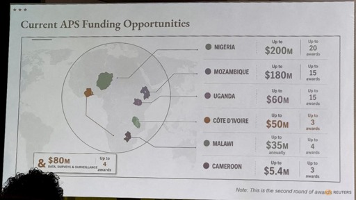
A Reuters analysis found the image of the map included in the presentation contained an artificial intelligence watermark that signals it was made with OpenAI tools.
Yeah, go figure. And they should be rightfully shamed for using AI to make a diplomatic presentation.
Clown show government
What’s weird about this is, whether you like it or not, chatGPT can generate an image of Africa with correct geography and country labels.
Not sure how they managed to fuck this up.
Probably used Grok lol
Grok’s owner is from Africa. Even Grok would have gotten it right. They decided to use their own knowledge.
Groks owner probably didn’t code from. Busy ignoring his kids.
A literal fourth grader wouldn’t have fucked this up, that’s how STUPID MAGAs are, even at the very top.
This is what I remind people of whenever MAGA starts threatening, and tries to intimidate everybody: They are Virtuosically Incompetent, and fuck up EVERYTHING they do, even really easy stuff like this. Everything they threaten is a bluff, and they are really bad at it.
Call their bluff Everytime, they are ALWAYS lying.
They are nothing to be afraid of. They are literally dumber than a failing fourth grader.
Did not know that - it makes it so much worse. They didn’t even bother writing a good prompt!
Now everyone is talking about this dumb “mistake” and not them cutting back funds for AIDS relief.
When is this going to stop? This minor issue was not intended as a 4D chess distraction.
Stop treating these people like strategic masterminds. They’re fucking stupid.
A Reuters analysis found the image of the map included in the presentation contained an artificial intelligence watermark that signals it was made with OpenAI tools.
I suspect some low-level staffer used a joke prompt, maybe expecting it to be flagged early on, and it escalated up the presentation life cycle through multiple layers of people who didn’t know or care.
Actually, they probably fumbled with the prompts for a while causing it to hallucinate.
They then didn’t notice the error because of a lack of basic understanding on the subject matter ánd didn’t think it necessary to scrutinize anything they put out in the world.
Are you starting to see the pattern?
AI may have amplified the problem, but the underlying issue, as usual, is incompetent people. We have an executive branch made up entirely of people who are slavishly loyal to Trump. Since only spineless idiots can qualify, that’s what we get across the board.
Yeah but AI enables incompetent people. I feel like having to work on something would make you learn enough not to fuck up too bad, generally. But with AI you don’t need to learn or research, you can just ask chatGPT to do whatever and call it a day, if you’re careless enough
Those are made up shapes, too.
I mean, this is the country that keeps getting the Gulf of Mexico wrong…
Everything is so stupid.
No, mostly just the US.
I’ll say, the U.S. is openly trying for stupid harder than I’ve ever seen any other country try!
The fact the Ivory Coast is land locked in this should have been an alarm to double check it.
The country highlight on the far west side is killing me. The line from it doesn’t point to anything!! Are you saying that country has moved?!
I like that the Ivory Coast is not only in the wrong spot, it’s not actually on any coast. It’s right in the name.
Only if you can read a language other than English. Some people are probably wondering why they wear special coats in that African country.
Jesus fucking Christ, it’s like they’re TRYING to embarrass our entire nation from every single department possible. 10 years ago this would’ve amused me more than anything, even if only slightly. But now? Everyday is just another brand new stupid example of our own incompetence with somewhere around a 50/50 split between embarrassing and infuriating. I’ve never been a gung-ho, America-first, capital-P “Patriot”, but I never would’ve even conceived that we would sink so low so quickly; every new rock-bottom simply becomes a new surface-layer to be strip-mined of any remaining shred of dignity, empathy, and humanity
These guys could strip mine NYC’s bedrock with how hard they dig